|
Gerenton
Cemetery
Description
of Gerenton from W.P.A. Files, 1936-1938.
Carroll, County, Mississippi.
Old Gerrington, eight
miles from Vaiden, was settled by a man named McLemore. He was very wealthy, owned quite a bit of
land, and his home, built here in 1850,
is still standing. Claib.
Nelms, Dr. Sanders, and Dr. Gerring, were the next
homesteaders.
A general merchandise store, drug store, school,
and a Baptist Church were soon built here.
Gerrington lacked only one vote of
being selected as the state capital. [Ed. Note: This was told to the W.P.A. Researchers by
Mr. J.M. Wright of Vaiden,
MS, during the W.P.A.’s report
in the 1930s. It is incorrect. Middleton was thought to have
missed becoming the state capital by only seven or eight votes.]
Description
of the Gerenton
School from W.P.A.
Files, 1936-1938. Carroll
County, Mississippi.
Old Gerrington, located
eight miles northwest of Vaiden, was established about 1846, as nearly as can be ascertained.
The building was an old dwelling consisting of two
rooms, but later the partition was removed, making one large room. Miss Lizzie McCarroll
was the first teacher, and, McGuffey’s Reader, writing, Davies’ Arithmetic,
and Webster’s Blue Book Speller were the studies. Some of the prominent citizens who attended
this school were Tom and Bill Hamilton, John Daton
(or Deaton), Frank and Jennie Hawkins.
This school was abandoned during the War Between the States.
Source: Mississippi Department of Archives; Carroll County
Cemetery Records and Carroll County
Mississippi
Census of 1860.
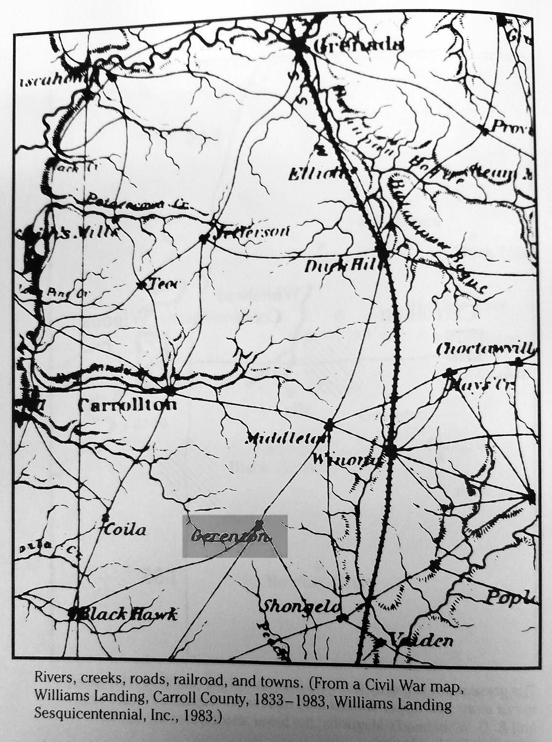
Directions
to this cemetery are vague, but are listed as: “Leave Carrollton Courthouse on Highway 35, and go south about 9
miles. The cemetery is
northeast of this point about 3 miles.” One map alludes to the fact that Gerenton might have occasionally referred to as Summerville,
named after the school that was located there. There is no listing for Summerville on the U.S. Geological Survey, although there is a
listing for Summerfield Church, which, according to the U.S. Geological Maps, is the same
location. The name on the map listed
in the text above was possibly misspelled, or the Survey has the name listed
incorrectly. There is also a listing
for a Summerfield
Cemetery, located in
the same vicinity. Summerfield Church
is listed at Bailey Lake at a latitude of 33 degrees 24
minutes and 06 seconds
North and a longitude of 089
degrees 49
minutes and 53
seconds West, as seen in the following images: Image 1 Image 2 Image 3. Summerfield
Cemetery is listed also at Bailey Lake at a latitude of 33 degrees 24 minutes
and 07 seconds North and 089 degrees 49 minutes and 56 seconds West, as seen
in these images: Image 1 Image 2 Image 3.
Another Map Showing Gerenton’s Location
Another
source, the W.P.A. Files of 1936-1938 list Bryantville
as the town that was formed from Old Gerenton
around 1900. According to these files, Bryantville, located in approximately the same location
as the town of Gerenton,
became extinct around 1920. Although the exact latitude and longitude
of Gerenton are not listed on the U.S. Geological
Survey site, Bryantville’s coordinates as listed as
being located at Bailey Lake with an altitude of 420
feet, and geographic coordinates of 33 degrees 23 minutes 35 seconds North and 089 degrees 49minutes 26 seconds West, as seen on these images:
Image 1 Image 2. The U.S.
Geological Survey also lists alternate names for Bryantville
as Gayden, Geren, Geren’s Crossroads, and Gerenton.
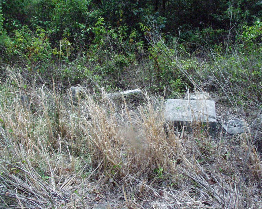
On August 16, 2000, I visited the Gerenton Cemetery, thanks to Bob Ellis of Winona.
According to Mr. Ellis and his research, although the Gerenton
Cemetery has only 10 known markers, these markers
were set apart from the rest of the cemetery.
This smaller plot contains the markers indicated in the list
below. It is estimated that several
hundred people are buried in Gerenton Cemetery, however there are NO markers on the graves
in the location of the main cemetery which, according to one source, was
approximately two-acres in size. In
the past, old cemeteries were robbed of their markers to be used for
resale to grieving families. The
robbers had the markers’ names removed and new names were added in order to
be resold. It is believed that the
main portion of the Gerenton Cemetery
was robbed of every marker. According
to my personal research of the Carroll
County Mississippi Census of 1860, Gerenton
lists approximately 293-312 residents (168 White Males and 144 White females). Of those, one was blind (age 46), one was deaf and dumb (age 11), and one was listed as a
pauper (age 10). It is unclear why the census would list a 10-year-old as a pauper, except
that no one else on the Gerenton census had the
same last name, indicated that this youngster possible was adopted, or own
his own. Since the Census of 1860 only covers FREE
INHABITANTS, no colored persons were listed.
After examining the Carroll
County Censuses of 1840, 1850, 1860, 1870,
and 1880, the 1860 census is the only one
that lists Gerenton, indicating that the town’s
life as a “voting precinct” was short-lived.
Here are two of the eight pages of the Gerenton
1860
Census: Page 13 – Page 14
The
1860 U.S.
Census for Gerenton, MS, is on Roll 578, call # MM312.09; micro copy M653, 4th Police District of Carroll
County, is located in the Mississippi Department of Archives, and, from the
microfilm, indicates that this information is contained on Pp. 13, 14, 15, 16,
23, 24, 26, and 41 of the 1860 Carroll County Census Books. The Real Estate
valuation for all inhabitants listed on the census is $283,370.00 and the Personal
Estate valuation is $704,050.00. The totals on the census were taken from
the highest number listed as some pages had been recalculated by the
enumerator, who marked through the old totals and wrote the corrected totals
below the original figures.
Some
names and occupations were very hard to read, due to the enumerator’s
handwriting, but family names in Gerenton included
the following (the names with a ? beside them indicate possible error in the
interpretation of the handwriting):
Anderson,
Baskerville, Baskins, Billingsley, Bragby/ Bregby?,
Collins, Colmery?, Compton, Davis, Duren, Durham, Gaden, Gardner, Gee, Gisdell,
Gooding, Gosey, Grear,
Gunn, Hamilton, Holman, Howell, Jackson, Johnson, Kelly, Kendall, Mahony,
Marshall, McCaskill, McKinney, Miniard, Nail,
Nelms, Perkins, Pullen, Purnell, Rogers, Ross, Russell, Saunders, Stafford,
Stafford, Stedman, Stone, Trotter, Ward, Wells, Whitehead, Wood, Wright,
Young, Yumerrtine?. Note that the founder of Gerenton,
Abraham Geren, (or anyone listed at the bottom of
this page) is not listed on this census, due to the fact that everyone on the
list at the bottom of this page was deceased by the time of the 1860 Census. Of those 10, Abraham Geren was
the last to die.
As
listed on the 1860
Census, families of Gerenton were originally from
Georgia, Mississippi, North Carolina, South Carolina, Tennessee, Virginia,
Alabama, Louisiana, and New Hampshire.
In addition, one resident was born in a foreign country and 88 children were enrolled in
schools during that time.
The
town of Gerenton
was located about 1
to 2 miles away from the cemetery,
according to Mr. Ellis. Several years
ago, he visited the Gerenton Cemetery
location with a Colored Gentleman, who remembered the details of the cemetery
before its desecration. At present,
plans are underway to transfer this videotape to a .mpeg file, to be stored
on CD-ROM for archival purposes. If
anyone reading this knows the person or persons responsible for the
desecration of the Gerenton
Cemetery and the removal/resale of
the markers, please inform the Carroll
County Mississippi’s
Sheriff’s Office at 662.464.5221,
or contact the Carroll
County 2nd District Courthouse
at 662.464.5476.
The
CORRECT directions to the cemetery are as follows (as of August, 2000):
From
Vaiden, go north on Highway 51
about 7 or 8
miles until you see Gum Branch Road on the left (this road
is 4 miles south of Winona, and coming
from Winona, it will be on your right).
This is a dusty, winding, dirt road.
Turn west on Gum Branch (going north, you will turn left; going south,
you will turn right) and follow the road, keeping to the left at every
fork. After exactly 3.6
miles, you will cross Gum Branch Creek (there are no signs,
only a small bridge). There is a
cattle gap on the left (the first road past the bridge). Gerenton Cemetery
is in this area, but you will need to walk, or have a Four-Wheel-Drive to get
through the ruts. Finding the
gravesite will take a lot of time, because of the undergrowth. Simply stay on the little rutty roads until
you see a yellow stake
about 5 feet tall. It is on the corner of the road that goes
past the gravesites. Turn at the
yellow stake and go approximately 100
to 200 yards until you see pine trees with orange markers (ribbons) on
them. The gravesite is within this
thicket. If you keep going past the
cattle gap, and stay to the left at every fork, Gum Branch Road turns into Carroll County Road 278, which comes out on
Hwy. 35, about 7 miles
west of the I-55 bridge at Vaiden.
The
second, and LEAST DESIRABLE
ROUTE, is as follows (as of August, 2000):
From
Vaiden, go west on Highway 35. From the Interstate 55 Bridge, go about 7
miles until you see Carroll County Road 278. This is a winding dirt road, and, going
west (toward Carrollton)
on Highway 35, the road will be on your right. Follow this dirt road approximately 3.1 miles, bearing to the right
at each fork. This is Gum Branch Road. You will see a cattle gap on the
right. This is the entrance to the Gerenton
Cemetery site. Take a cell phone and plenty of water with
you. It is extremely hard to find
these graves. However, plans are also
underway to clear as much of the area as possible and to restore as much as
possible of the remaining cemetery site.
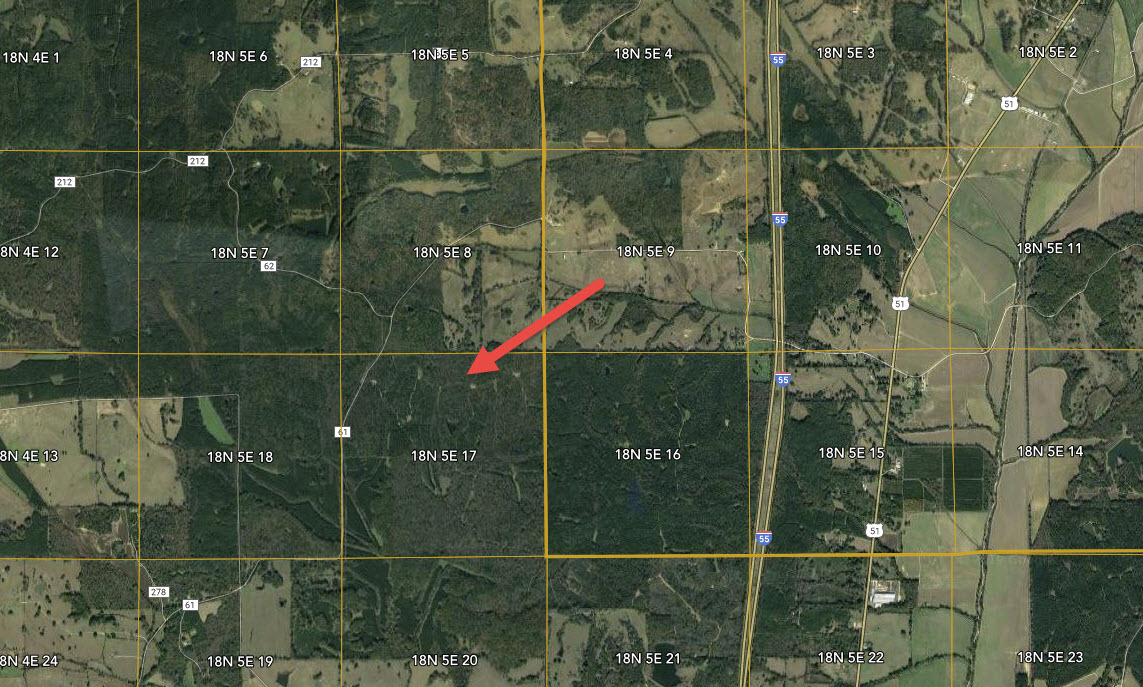
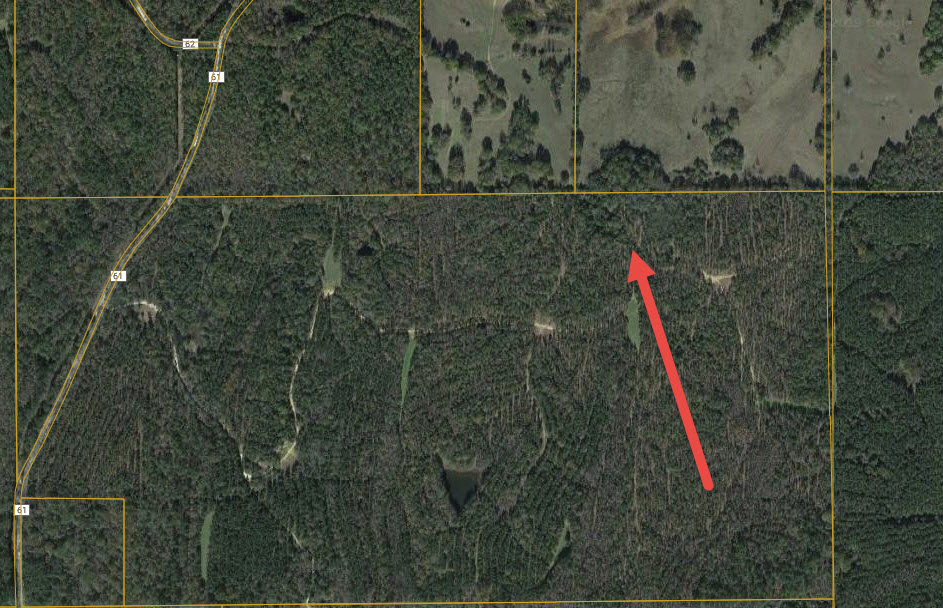
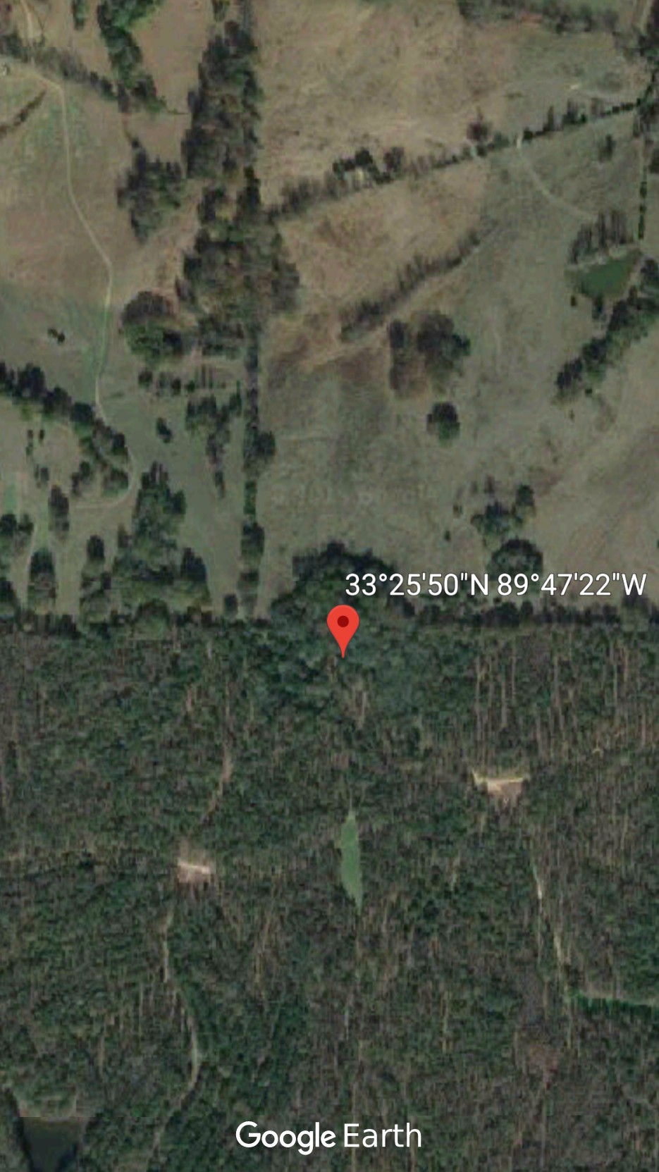
Possible Location of the Gerenton Cemetery via Aerial Photos and GPS
Image 1
Image 2 Image 3
THIS IS PRIVATE LAND.
DO NOT ENTER WITHOUT PERMISSION!!!
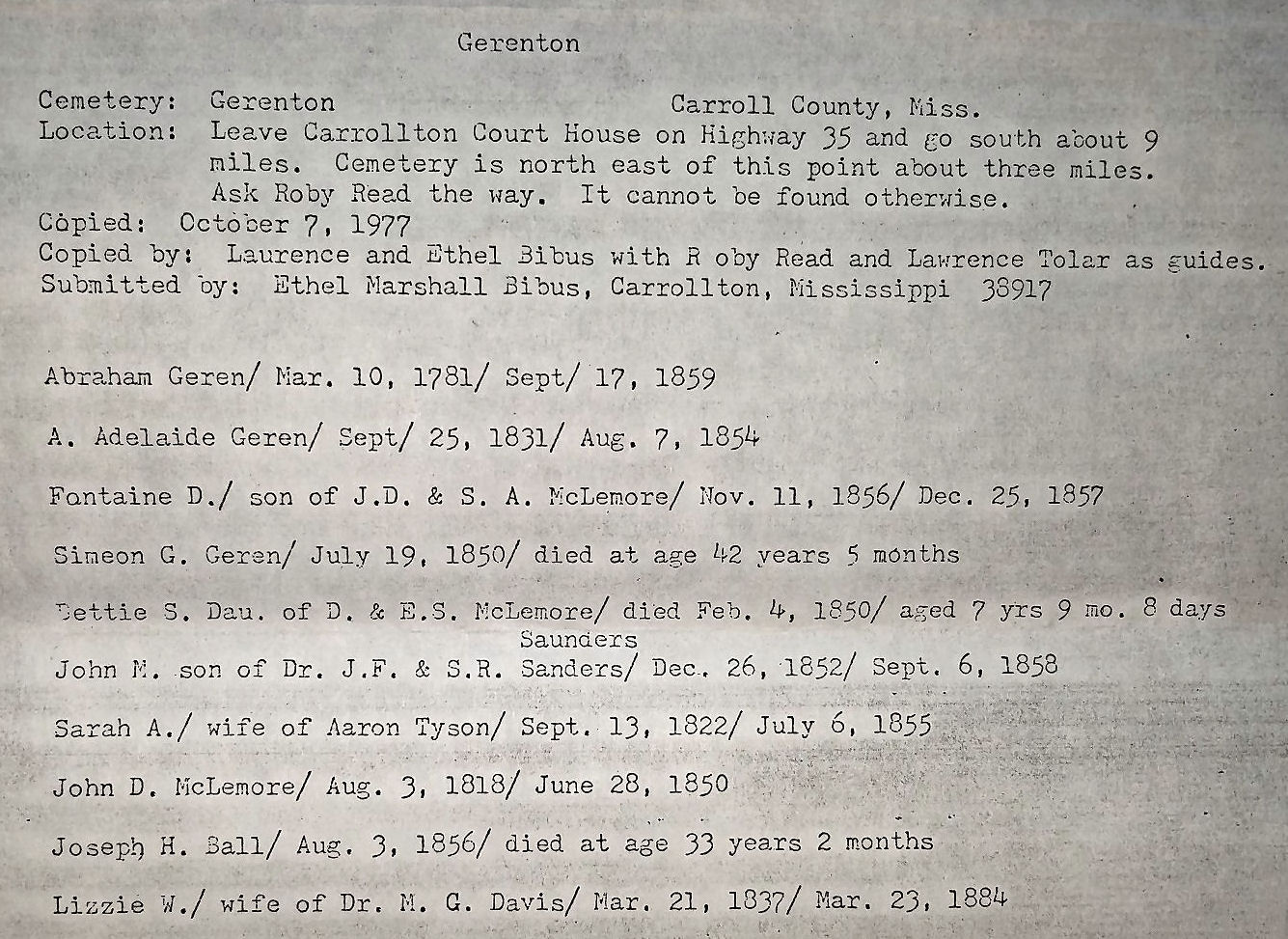
Although
I did not find all of the markers listed below on the August 16, 2000 visit, the list below was taken
from the Carroll County Cemetery Records as documented by Ethel Bibus of Carrollton,
MS.
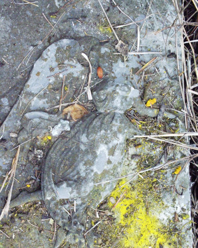
Abraham Geren – 03/10/1781 – 09/17/1859 - Age: 78 years 6 months 7 days
Marker Photo 1 – Marker Photo 2 – Marker Photo 3
Geren Family Plot
Apphia Adelaide Geren – 09/25/1831 – 08/07/1854 - Age: 22 years 10 months
13 days
Marker Photo 1 – Marker Photo 2 – Marker Photo 3 – Marker Photo 4
Fontaine DeGraffenried McLemore, Son
of J. D. and S. A. McLemore – 11/11/1856 – 12/25/1857 - Age: 1 years 1 months 14 days
Marker Photo 1 – Marker Photo 2 – Marker Photo 3 – Marker Photo 4
Simeon G. Geren – 02/19/1808 –
07/19/1850 – Died at 42
years, 5 months
Marker Photo 1
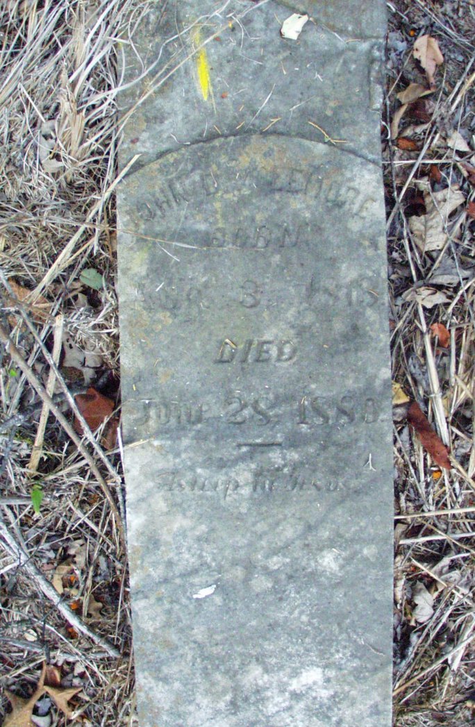
Bettie S. McLemore, Daughter of D. and E. S. McLemore –
04/26/1842 – 02/04/1850
– Aged 7 years, 9 months, 8 days
John M. Sanders, Son of Dr. J. F. and S. R. Sanders (or
Saunders) – 12/26/1852 – 09/06/1858 - Age: 5 years 8 months
11 days
Sarah A. Tyson, Wife of Aaron Tyson – 09/03/1822 – 07/06/1855 - Age: 32 years 10 months
3 days
Marker Photo 1 – Marker Photo 2
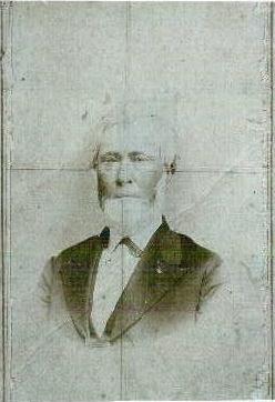
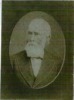
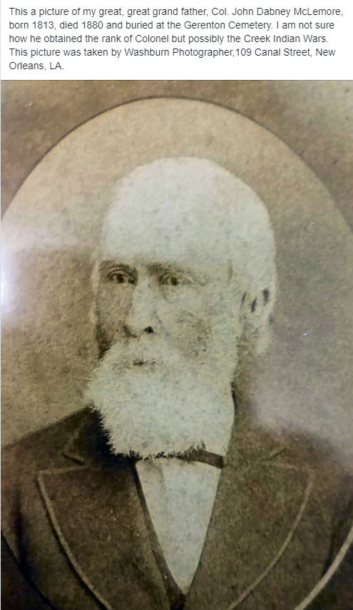
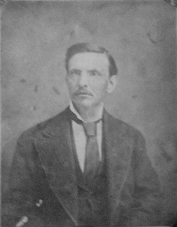
John Dabney McLemore – 08/03/1818 – 06/28/1880 - Age: 61 years 10 months 25
days
Marker Photo 1 – Marker Photo 2
Photo 1 of John D. McLemore was taken in Memphis, TN, by Y. Day, 338 Main
Street and has no date.
Photo 2 of John D. McLemore was taken by Washburn Photographer, 109 Canal
Street, New Orleans, LA.
Photo 3 of John D. McLemore was taken by Washburn Photographer,109 Canal
Street, New Orleans, LA.
All negatives
preserved since 1864. Photos Courtesy
of Baird Moor.
Photo of Sarah (Sallie) Ann Geren
(John D. Mclemore’s
Wife)
Joseph H. Hall – 06/03/1823 – 08/03/1856 – Died at 33 years, 2 months
Lizzie W. Davis, Wife of Dr. M. G. Davis – 03/21/1837 – 03/23/1884 - Age: 47
years 0 months 2 days
Marker Photo 1
OTHER PHOTOS
Photo 1 – Photo 2 – Photo 3 – Photo 4 – Photo 5
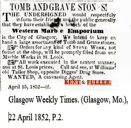
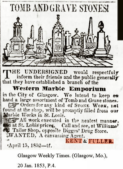
Mason Marker – Monument Manufacturer – Map of Gerenton Road
Marker Manufacturer Kent & Fuller, St. Louis, MO – Advertisement 1 Advertisement 2
Addie McLemore Wedding
Announcement (out of focus)
Addie McLemore Photo (front)
Jeff McLemore Photo 1
– Jeff McLemore Photo 2
(Jeff was the son of J.D. McLemore (Addie McLemore’s brother)
and husband of Mollie Watkins of Carroll County)
Photo of Jeff and Mollie Watkins McLemore
Photo of Ethel Bibus’ Gerenton Cemetery List
Gerenton Information
Source: Mississippi Department of Archives; Gerenton Subject Files, and Mr. and Mrs. Bob Ellis of Winona, MS.
Subject Files, Page 1 – Subject Files, Page 2 – Subject Files, Page 3
Map Showing Location of Gerenton
Choctaw Session Map
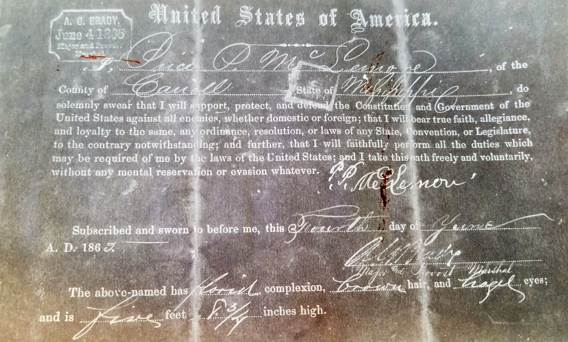
Affidavit
from Price P. McLemore (son of J.D. McLemore) dated June 1869 pledging
support for re-admission as a citizen of the United States
-------------
From: http://msgw.org/carroll/history/townhist.htm
Gerenton
Webmaster Note: The
information below is not thought to be 100% accurate. Those statements that
are known to be inaccurate are highlighted in brackets ([ ]).
Located
in Carroll County to the east of present day Coila
and south of Middleton/Winona, this town was settled in 1832 by Colonel
[J.]D. McLemore, followed by settlers Nelms, Sanders, Abrahams and Geren, the town being named for the Gerens.
Other settlers followed with a general merchandise store, an apothecary, a
school and a Baptist church being established.
[Early
records indicate that Gerenton missed being
selected as the state capital by only one vote.]
At
the outset of the Civil War, two of the most prominent men in the state lived
there: Colonel John Dabney McLemore and Major Frank Hawkins. Colonel McLemore
was said to be the largest property taxpayer in the state, and Major Hawkins
reputed to be the wealthiest man in the state. Colonel McLemore maintained
residences in Franklin, Tennessee, Coffeeville and Gerenton,
Mississippi, and New Orleans, and was a business associate of Andrew Jackson.
Major Hawkins was a direct line descendant of the Hawkins admiralty that
defeated the Spanish Armada. His ancestors in Warren County, North Carolina
were publicly recognized as "the finest family in North Carolina".
The
Gerenton Cemetery was said to be the prettiest
little cemetery in Mississippi, containing over 150 magnificent monuments and
500 graves surrounded by a beautiful wrought iron fence, with members of some
of Carroll County's oldest and finest families being buried there.
Apparently,
following the transition many small Mississippi settlements experienced,
people moved to the newer towns where railroads, new commerce and hopefully
more opportunity abounded. [The Gerenton post office
closed around the time of World War II and the town died.]
-------------
Site
Design Copyright – 09/15/2019

|